 |
Great Pond Mountain
Nothing beats stress quite like hiking. For me, the blast of fresh air, the smells and sights and sounds, the solitude... it is the best remedy from the everyday stresses. This week has been hard one for sure, thus it is time for an escape.
What better place for that escape than the 4,300-acre Great Pond Mountain Wildlands, located just a short drive away for me, in East Orland.
It was a Tuesday evening, and the sun was just setting. I was just arriving at the Hothole Valley South Gate. The forecast called for fairly mild temperatures that night, expected to be just below freezing. A perfect night to play with my new shelter system. I was looking forward to practicing setting it up by headlamp. Also, there was a bit of a drizzle, so I would also get some practice setting it up without wetting my gear in the bad weather.
My plan was to hike a short distance in, setup camp, then spend the next day hiking. With my backpack on, and trekking poles in hand, I begin down Valley Road into the dark of the night. It didn't take long for the sounds of the road to be drowned out, and for me to be entirely engulfed in darkness. I used my headlamp to navigate down the wide dirt and gravel road. It was a very serine and peaceful walk in the night.
Arriving where I intended to camp, I unrolled my backpack and began dispersing my shelter system. What I used was a HMG Echo II Shelter. This is an extremely lightweight shelter, made from cuban fiber. It uses trekking poles for setting up, eliminating the need for any additional weight in tent poles. For me, I feel this shelter is ideal for my upcoming planned excursions. It is a balance between the best qualities of a tarp, and the best qualities of a tent.
As I began setting up my shelter, the drizzle picks up, and becomes a light rain. I quickly got the tarp started, using trekking poles on each end, and staking out the tarp. I was able to then remove my remaining components from my pack from underneath the tarp. I feel I was pretty successful at getting camp set up without getting my gear wet. This is a critical skill if you plan on doing any serious backpacking in bad weather.
Laying in my sleeping bag that night, I was amazed at how warm it was for mid January. It was going to drop below freezing that night, but not until just before dawn. I fell peacefully asleep to the sound of rain on my tent.
I woke with a shiver. It was so mildly warm last night, that I fell asleep barely covered in my bag. Temperatures dropped significantly overnight. I needed to get out and pee anyways, so I figured I would walk around camp and warm up.
Stepping out of my shelter, I noticed the tarp was covered in ice! I was very impressed how well my setup has survived these conditions. The inside was completely dry, the outside still tight as a drum. Very pleased that I can trust my home away from home.
As I walked around, my eyes laid on a beautiful sight; the sun had just started peeking over the ridge, and was lighting the peak of Great pond Mountain in bright gold light. It was an inspiring sight, and filled me with an optimistic energy.
I broke down camp, leaving not the slightest trace of my being there. I cooked some sweetened oats on my Jetboil stove, then continued on down Valley Road.
Shortly after departing camp, I came to a sight that made me chuckle. A former outhouse, apparently now claimed by the porcupines of the Wildlands!

I began down Hothole Brook Trail. This is a wide multi-use trail, just under a mile in length. I crossed Hothole Brook by way of a well-built bridge, and observe beaver huts to my right.
 Hothole Brook
 Trail continues past some large boulders, one of which I found particularly interesting. It had a large tree growing from it's top! It was an amusing sight to me! The trail ends in a clearing, just below 1,020 ft. Great Pond Mountain.

The highlight of this trail was actually a short path that branches off of it. Bump Hill Path, a very enjoyable, albeit short, scramble up and around and over glacier-dropped boulders. It was a fun little loop, one which I highly recommend should you decide to visit the Wildlands (and indeed you should). The reward for climbing the hill was very nice. It afforded an excellent view of the surrounding mountains, and overlooked an interesting wetlands area. I intend on returning here in warmer months, and would not be surprised to spot some great wildlife. Here is a quick video I shot to give you a taste of the view from Bump Hill.
Heading back out the way I came, I crossed Valley Road, and headed through Red Pine Path. This short trail meanders from an old road onto a footpath, which took me by Cascade Brook and through nice forest.
I then began heading East on Flag Hill Road. This starts out as a wide open roadway, affording nice views of surrounding ridges. It then narrows up a bit, and becomes a "Trail". The trail then becomes Flag Hill Path, which ascends a more difficult and steeper stretch to the summit of Flag Hill.
 View of Branch Lake and beyond from Flag Hill summit
At 925 ft. tall, Flag Hill's rock face summit allows you some absolutely astounding views of the surrounding area. In the distance, you can see places such as Acadia National Park, and Camden Hills. I could spend a day here to just relax and think, and would be perfectly content.
 View from Flag Hill
I had hoped to continue from Flag Hill deeper into the Wildlands, and planned to spend another night out there. However, I utilized the cell signal from atop this mountain to check the weather forecast. To my dismay, the original reports of another mild night had changed, and I was instead looking at significantly colder temperatures ahead. I was ill prepared for such temperatures, having packed only what I needed for the original, much warmer, forecast. So I pulled out my map and decided on another route that would make the most out of my day, but lead me back to the South Gate.
Before leaving Flag Hill, I shot another video to share with you, of the views from this summit. It isn't stunning in quality, but if the videos prove to be a nice touch, then I promise to improve on them in the future!
I headed back down and out via Flag Hill Trail, then cut across onto East Ridge Path. After crossing Hemlock Brook,this path brought me through dense hardwood forest, gradually climbing atop Oak Hill. After crossing exposed rock summit, the path opens up to offer splendid views of the Wildlands and beyond.

The trail then descended steeply down the west side of Oak Hill. It emptied out on Hillside Trail. this section of Hillside was a wide trail offering open views of Great Pond Mountain.
I thought to myself at this point about how much I enjoyed the diversity of the trails here. You can string together several short trails, some are narrow, rocky scrambles up hills or through thick woods; Others are wide and gently rolling, but offer open viewing. It makes for an interesting experience, and you could compose a variety of different trips through these well thought networks of trails and paths.
I hopped off of Hillside, cutting across on the entirety of the 1.2 mile Esker Path. Esker has proven to be one of my favorite trails in the area.
 Esker Path
 is a classic New England trail. It is rocky, wooded, and diverse. It takes you through different types of forest, winding up and down, over root and rock, crossing several streams. It crosses a wetland area, requiring you to balance on carefully placed log foot bridges. This pleasant trail just plain feels good to hike. It was a great note to end my trip on.
 Ice adds some challenge to areas of Esker Path
Esker ends on Valley Road, a short distance from South Gate, where I am parked. The sun was setting, the chill was beginning to set in, reality of normal life was beginning to return once again. But I now feel very rejuvenated.
Great Pond Mountain Wildlands offers its visitors a variety of experiences. One could enjoy a few miles of easy walking, or put in some longer, harder miles that are very rewarding, or even spend a night or two for an all-encompassing experience.
I am already planning my return to this great place. The beauty and solitude it offered me proved addicting. I look forward to coming back and bagging Flying Moose Mountain, which is described as a "strenuous" climb. I enjoy a challenge! I also must summit Great Pond Mountain itself. I guess my one complaint is that there currently isn't a way to string in that summit from the Hothole Valley area. Instead, I must make a separate trip to Dead River Gate to gain access. A small price to pay, I am sure, but it would be nice to reach that area by foot from within the rest of the trail system.
The outdoors has it's affect on me, and that affect is among the best. I am drawn to the wilderness, whether it be the views, the education, or the challenges, I will never tire of the adventures afforded by our remaining remote areas. I am greatly satisfied by the opportunity to explore the Wildlands, and yet at the same time I am invigorated and am ready for more adventure!
I look forward to writing of my next Outdoor Wanderings. Thank you for taking the time to read along. I leave you with one last view from within this wonderful place.
 For more information on Great Pond Mountain Wildlands, including a very well written map and trail guide, please visit http://greatpondtrust.org/ Camping overnight in the Wildlands requires permission. For more information, visit the site or email your questions to info@greatpondtrust.org The folks I spoke with were very helpful and friendly. Their work here is greatly appreciated! |
Showing posts with label Maine. Show all posts
Showing posts with label Maine. Show all posts
Saturday, January 28, 2012
Great Pond Mountain Wildlands, Orland, Maine (1/24-1/25/2012)

Tuesday, January 24, 2012
Odd Winter Weather

So here I am, I have the next few days off, some new equipment to try, and an itch to head into the woods. If there is one thing Maine is not shy on, it's places to hike. I am trying to figure out an ideal place for an adventure for the next few days, that fit my current agenda.
Normally at this time of year in Maine, I would require snowshoes and gear to take me down to sub-zero temps. But as I look out the window now, it looks like Spring is practically upon us. It's a wet one, but that is a fine trade-off for the absence of cold.
I need to take advantage of this weather. I would love to just go out there now, and get an early start, but alas responsibilities require tending to. However I could utilize this eve, and take advantage of the next few days. Oh, the possibilities!
Looking ahead at the forecast for the next few days, it does appear the temperature will drop a bit, but it shouldn't be real cold at all in the next few days. Also it appears there won't be much chance of precipitation. Sounds perfect to me.
Well, the spirit that is Mother Nature has spoken, and has successfully convinced me that an escape into the wilderness is just what I need right now. I am still working on the details of exactly when and where, but I look forward to writing about my experience on here afterwords, and I hope you will care to read it.
Happy trails and cheers to a good adventure!
Friday, January 20, 2012
Fields Pond, Holden, ME
Deciding to ring in 2012 with style, me and a few friends decide to take a stroll at Fields Pond on the second day of the new year. Starting late in the afternoon, we didn't have long to spend, but this simple Audubon area offers a leisurely walk through some very pretty woods.
 Fields Pond Audubon Center offers a variety of natural habitat, ranging from fields to forest to wetland. The sanctuary is 192 acres and offers meandering trails throughout. There is an impressive visitors center and volunteers provide family activities. This appears to be a great place to bring children.
 We start our short trek by taking Ravine Trail. This is a pleasant walk through forest, with a gentle slope, overlooking a nice brook at the bottom of the ravine. The temps were cold enough to freeze the water, despite the odd winter we have experiencing this year. usually by this time in the season I would be snowshoeing. Not this year, however.
 The trail eventually loops around, and we decide to take Brook Trail to our left. This trail has us cross a couple brooks and takes use through a less dense area of forest. At one point on this path, we spot a group of wild turkey.
We eventually connect with and follow Lakeshore Trail, which brings us to an opening by the pond. With benches and nice view, this would be a great destination to break for lunch on a summer afternoon, and watch wildlife and enjoy a breeze.
We spend some time enjoying the sunset, radiant with color over the frozen pond, before following Lakeshore Trail back out to the parking lot.
 Fields Pond is not a challenging area to hike by any means. What this place offers is a nice trek through pretty habitats on well maintained trails. It is a great place when you wish to take a peaceful stroll in the woods, and it seems to me to be an excellent opportunity for young children to experience and learn about the outdoors. Whatever your reason for visiting, this is a great resource and a privilege for anyone to enjoy, right in the backyard of Bangor, Maine.
to learn more about Fields Pond, visit: http://www.maineaudubon.org/explore/centers/fpond.shtml#trails


We eventually connect with and follow Lakeshore Trail, which brings us to an opening by the pond. With benches and nice view, this would be a great destination to break for lunch on a summer afternoon, and watch wildlife and enjoy a breeze.
We spend some time enjoying the sunset, radiant with color over the frozen pond, before following Lakeshore Trail back out to the parking lot.

to learn more about Fields Pond, visit: http://www.maineaudubon.org/explore/centers/fpond.shtml#trails
Borestone Mountain, Elliotsville, ME

Thanks for stopping by! I thought I would do a little recap here of a fun adventure I had following Christmas just a few weeks ago, and to share the wonderful photos taken by my friend Kimberly Hammill.
Kimberly and I decided we should embark on a hike, and we had hoped to choose one that was challenging, offered great reward, yet was one we could do in a matter of a few hours. Borestone immediately came to mind.
I had engaged in hiking up Borestone Mountain a few times before, and felt it was a perfect fit for what we were looking for. In the warmer months, this mountain proved to be a quick and steep ascent, and with it's bare summit and prime location, it affords breathtaking views. It also fit our limited schedule as well, because it is only a few miles from trailhead to summit.

We arrived at the trailhead, and began down past the gate. Just past the gate, you have your choice of paths. You can either choose to continue forward down the Access Road, which is just a wide dirt road leading directly to the visitor center by Sunrise Pond, and the Summit Trailhead. Or you can opt to take the more primitive Base Trail, a .8 mile trail which brings you steeply through mature forest. In all subsequent visits I had chosen to take Base Trail, and this time was no different. Or, at least, it began so.
We hadn't made it very far on Base Trail before realizing it was going to be far more difficult than we had anticipated. We enjoyed making the attempt, aside from a few falls. The loose snow gave way to ice, and our boots just simply did not grip it well.
We pushed a ways, but after slipping a few more times, I stated that this was going to be too difficult without spikes, which we did not bring. So we decided to bail on the Base Trail attempt, and head back for the easier Access Road. My fear was that the Summit Trail could prove to be just as icy, or possibly even worse, given the steep grade. Worse case, we would get nice views from the base of the mountain, and of the alpine ponds, so all would not be lost.

So on we went, down the much easier Access Road. The scene was beautiful, white with snow, watching red squirrels dance about the tree branches.
A little beyond the halfway point, there is a short trail to the right that takes you to a nice overlook. This trail is accessible from both the Access Road and Base Trail. It's nice, because not even a mile in and you already have your breath taken away by the view. We stopped and enjoyed the overlook, which offers an expansive picturesque view of Greenwood Pond.
 |
| Greenwood Pond |
We had continued down the Access Road, passing bathrooms on our right. The restrooms are closed this time of year, but offer a nice luxury for hikers in warm seasons. A little further, and you come to pass a visitor center, also closed for winter.
Shortly, We had come to Sunrise pond, and an exquisite view of Borestone Mountain. It has a formidable appearance, despite it being relatively small compared to many of the area mountains. The exposed rocky summit gives it a more hardcore alpine image. That same exposed summit affords incredible views of the surrounding mountains. I just hope we can make it!
 |
| Borestone Mountain |
The Summit Trail begins by wrapping around the pond, and has you balancing on logs and boards over a few small streams.

Once around the pond, the trail begins a steep climb up through dense spruce forest. While fairly steep, the trail proved passable despite the ice. This has been made possible by the addition of stone steps in some areas, thanks to the Maine Conservation Corps. Numbering 130 in total, the steps provide us with ample footing to make it quite a ways up the mountain before coming across more challenging areas.
Once we had arrived to a point where teases of views began appearing, the trail became significantly more difficult, due to the snow and ice. We had encountered a few hurdles, steep areas of trail that had become a sheet of ice, offering little grasp. It was doable, and I encouraged my friend to continue as well. She is not as experienced a climber as I, so this challenge was foreign to her. So I would go first, showing her how I did each part, and she followed, sometimes reluctantly, but we pulled through, and were always glad we did.

We were almost to the top, just shy of summit, and the views were already absolutely incredible. The challenges to reach the top increased as well, however.
After passing another steep, icy climb, one that tested our limits, we came to what appeared to be a last final test. The hardest of all, however. To reach the very top, there was this short gap, followed by slanted rock. The slanted rock, of course, was all ice. It would be a long drop should I fail.
I stood there, contemplating a possible route. I had decided on the best way, however it would be a risk. I also could not see a way back down that wouldn't prove ugly. I turned to my friend, and told her this was as far as we are going. We looked around at the awesome views, and we were okay with that decision.
All in all, it was a great and exciting climb for a modest mountain. The winter conditions added to the challenge, and even caused us to fall short of the summit. It would have been safer had we brought spikes, though that last challenge just under the actual summit would probably feel safe only with an ice axe as well!

I will have to return here again someday in the near future, because for a few hours of hiking, you get great mountain views and plenty of enjoyment.
photos provided by permission by Kimberly Hammill.
to learn more about Borestone Mountain, visit: http://www.maineaudubon.org/explore/centers/borestone/index.shtml
Sunday, October 23, 2011
Orono Bog Walk Orono, ME

The Orono Bog is a very fascinating place, a rare wetland environment where acidic peat has built up over thousands of years. It is a culmination of many different exotic plants and animals. I have decided to walk the bog on a nice, mildly breezy October afternoon with my friend, Tim.
Tim and I set off towards the wetlands, and are greeted by fresh air and a gentle breeze. It is a nice day to be outside. But then again, when isn't it?
My friend's motive is to take photos with his new camera, while mine is an escape from the grind and something to write about afterwords.
The first thing to catch our attention before even reaching the boardwalk was a large beehive up in a tree.

It's one reason why I love the outdoors in the fall. Any other time of year, this magnificent creation would have probably been clouded by leaves, and we probably would have passed underneath without taking notice.
As my friend takes some time to perfect his shot, I think to myself about just how amazing a creature the bees are, or the other colony-based insects that make homes here. How they take up a job, and specialize in the task, to ultimately work together for the good of their kind as a whole. It's just an incredible evolutionary development if you really think about it. And it works for them, too.
We reach the boardwalk and begin to walk along it. The Orono Bog Boardwalk is a stretch of "floating" planks that stretch 4,200 ft. in a loop to bring visitors closer to the natural features the bog has to offer. The boardwalk takes you from the edges to areas that are over 20 ft. deep with peat, or dead acidic plant matter. The 4 ft. wide boardwalk brings you safely over and around the bog, allowing one to get up close to the unique flora.
 |
| A red squirrel enjoys the boardwalk with us |
I have learned that the person responsible for this boardwalk being built was a man by the name of Ron Davis. a professor for the University of Maine, he found himself bringing his classes to the bog often. He had thought that this interesting place should be shared with the public, and so he began to pull the project together. The Orono Bog Boardwalk is now a reality, and is sponsored cooperatively by the University of Maine, the City of Bangor, and the Orono Land Trust. It has been designated as a National Natural Landmark by the National Park Service.
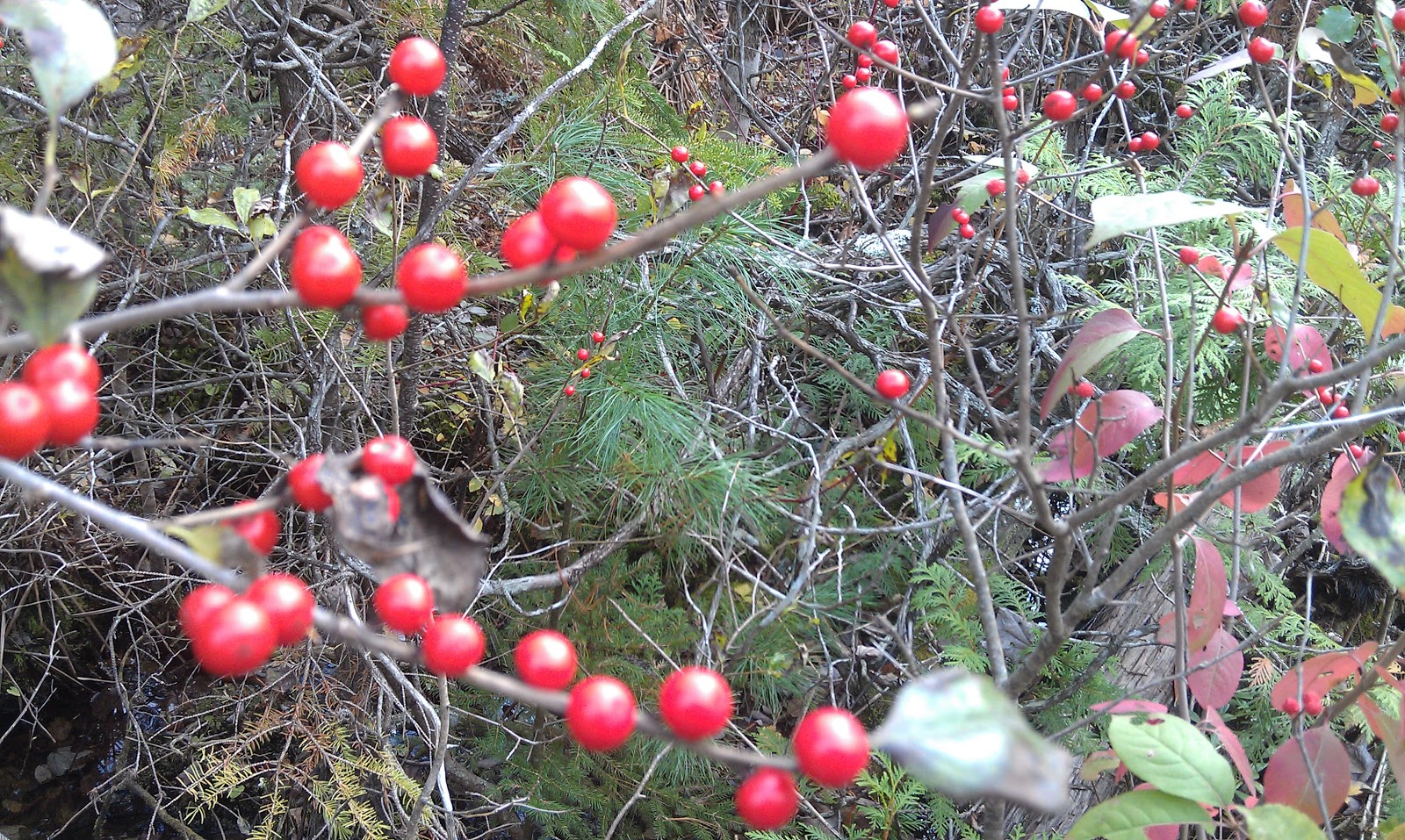 |
| "Through the Winterberry" This image I feel helps to capture the diversity of the bog |
As I proceed deeper into the bog, any remaining earth is replaced increasingly by areas of peat moss and other mosses. They thrive in this environment, specializing in floating above the peat, and in holding water and air.
 |
| Peat moss |
 |
| Pitcher plants |
And the insects can't make it back out. The insects drown in the liquid, and get broken down by enzymes into mineral nutrients that the plants can absorb. This I find truly fascinating. The pitcher plant has essentially developed a stomach, which allows it to withstand the harsh conditions of the bog. So what if there is no soil? This plant finds it's nutrients in a more creative way!
 |
| Looking down inside a carnivorous pitcher plant |
Out in the deepest parts of the bog, I come across a variety of unique plants, and a few birds. It all feels very low and open, allowing me to see a ways in the distance. At this time of year, most everything has a hue of a rusty red, dotted by the occasional patch of still green moss and white puffs of tall cotton grass. The boardwalk sinks a bit with each step, reminding me that I stand on around 25 feet of waterlogged and dead but not decomposed plant matter.
 |
| Tall cotton grass |
When we first entered the bog area, it began as forest. Out in the depths of the bog however, there is just one tree that is predominant over the majority. The black spruce tree has also adapted to the bogs. They have an appearance of being short young trees, but they are actually quite old.
The trees appear to grow in clusters. This is because the tree has special adaptions to the circumstances. As the mosses overtake branches of the tree, the now swallowed branches make roots, so that the tree is constantly clinging to the top. The tree clones itself with these rooted branches, forming genetically identical new trees. This is why there are clusters of these trees in the bog. the oldest trees are found in the center of the clusters.
 |
| Tree clusters |
The path slowly becomes more and more forested, and we gradually find ourselves looped back to where we started. As we make our way back to our car, I think about how much I have seen in just my short visit today. It brought forth the youth from within me, excited to experience and eager to learn. I look forward to returning here in the future, to see what the other seasons bring to my attention.
To learn more about th Orono Bog Boardwalk, please visit: http://www.oronobogwalk.org/index.htm
Saturday, October 15, 2011
Debsconeag Backcountry Loop
Hello and thank you for tuning in! This week, the adventurous spirit within me has brought me to the remote wilderness of the Nahmakanta Unit of the Maine Public Reserved Lands for what proved to be an exciting and inspiring overnight rendezvous with the lands Thoreau once referred to as "God's Country".
Driving into the wild lands proved almost as exciting as the rest of the adventure. As I leave the last glimpse of the civilized world in passing the Kokadjo Trading Post, and trade pavement for dirt, my adrenaline begins to rise. The bumpy and winding roads take me a good 25 miles into the heart of the forest, with views of remote lakes and mountains. The occasional bird or rabbit darts out before me. Every so often, I am reduced to crawl speed to navigate a particularly tricky area in which the road has been partially washed away, or a recently downed tree has blocked half the road.
After almost an hour of navigating windy dirt road by truck, I reach my destination, Fourth Debsconeag Lake. The weather proves beautiful, and Autumn is present in the colored leaves. I strap on my backpack and begin my journey down the Debsconeag Backcountry Loop.
 As I walk the trail, I feel instantly refreshed by the fresh air and solitude. This is where I want to be. The wilderness in any form just tickles my soul in a way that is hard to explain, it is only felt in places like this. There is a fire in me, and when it starts to dwindle, when society and the world has it all but extinguished to just a few glowing embers, I step into the wild, and that fire is stoked and fueled into an inferno.
I have chosen to bear right at the first fork, to head in the direction of Stink Pond and some of the farthest stretches of this back country. As I walk past Fifth Debsconeag Lake, I realize that this would be a great place to bring a fishing pole. I have not brought my fishing gear. My plans were for some great hiking, wildlife views, and solitude. It now hits me that I will be circling several hidden lakes and ponds, as well as crossing a few nice rivers. In fact, the translations for these places from the language of the Abenaki Tribe is "plenty of fish lake" and "ponds at the high place". I am sure the fishing would be incredible here.
Hiking along the Debsconeag Back Country Trail brings me through deep wooded, primitive trail. A lot of these woods are young, this area having been heavily logged over the years. Occasionally, I pass some evidence of the loggers, like at stream crossings where pins remain in rock, or where a portion of the lake remains dammed with earth. The loggers used to use these dams to flood the streams and lakes to move the timber along down the Penobscot River, eventually arriving at the mills.
The woods here, I noticed, are very green with mosses. It gives it such a lush appearance. It makes for a striking image at this time of year, with the contrast of the Fall colors. Dark, vivid green of mosses and pine, dotted with leaves of bright red, yellow, and orange. I could paint canvas for years and never quite capture the beauty the natural world has set before my eyes.
Hiking along side the aptly named Stink Pond, I begin to really notice the wildlife. Various birds hop around the trees above. Many squirrels making it well known they don't like having me around. I also begin to really observe the signs of wildlife. Footprints galore. Many areas of scat, I identify some as being moose and bear droppings, both of which I hope to see. At a safe distance would be preferred! Due to the many crunchy leaves I am walking on, I am probably loud enough that a close encounter is unlikely.
I begin to ascend to the ridges above Stink Pond, where the forest begins to loosen up a bit. The added sunlight from the openings in the canopy make the Fall colors really pop. It's a bit of a climb, working up a little sweat, but with nice reward. Finally reaching the ledges above, I am met with some nice views of the surrounding area. I spend some time here to catch my breath and marvel in the awesomeness of the mountains before me.
After passing through another stand of colorful trees, the path opens up to more ledges, and more views. I meandered through the cairns to an overlook that offers me a view of some ponds below. I observe the marshy ponds from my perch, and almost fall over in my excitement as I notice what appears to be movement! Trying not to jump to conclusions, I fumble through my backpack in search of my binoculars.
Fixing the view on my target, I am happy to say that I was correct, and that I was now watching a female moose, or "cow moose", in her most natural habitat! I watch for some time, as she grazes, and looks around, then returns to the marshy water she stands in. What a sight! I wait for a bull moose to come, which would be inevitable, but I could only wait so long, there's many miles to be covered, and I was more than content with what I have witnessed.
So I leave the large yet graceful beast to her routine, and I march forward. I dip into a large gap, passing more streams and dense forest. While I see many signs of wildlife having been in the vicinity, I hear nothing. Just the crunch of my own feet. I find it very peaceful.
Reaching the other side of the gap, I begin to climb again, reaching views this time of the beginnings of a mountain I will be climbing on this trip, Nesuntabunt Mountain. The slopes are lit with Autumn colors.
I descend from the hills, making my way past the very remote Seventh Debsconeag Pond, Then the larger but equally remote Sixth Debsconeag. The sun is beginning to drop behind the peaks, and the light begins to fade from the valley. I pick up the pace to ensure I reach my destination before dark.
Reaching the 3.5 mile long Nahmakanta Lake, I seek out and find an area suitable for camp. I start a fire, pitch my tent, then sit by the rocks along the shoreline, and wonder how such a large and inviting lake has managed to avoid being completely surrounded by log cabins and camps. I eat my oatmeal, and stare at my fire for a short time before the darkness surrounds me. Feelings of bliss and loneliness compete for my thought in the solitude of the night. Exhausted, I leave the thoughts outside as I crawl into my tent, and quickly fall asleep to the sounds of waves lapping the shore.
The next morning arrives suddenly with the realization I had overslept a bit. The cloudiness, paired with being deep in a valley, kept the sky somewhat dark and was the cause of my not waking. I don't mind the clouds, since the forecast had been for rain and currently it was just clouds with no rain.
Expecting rain at some point, however, inspired me to pack my gear and head out without much haste. leaving the Debsconeag Back Country Trail, I cross a bridge to take the 3/4 mile West Trail.
The West Trail is a short but exciting trail, quick ups and downs, as I pass huge glacial boulders that teeter on edges, dripping with various shades of green mosses and lichens. Toward the end of this trail is Rainbow Stream, a fast moving, shallow yet wide vein of mountain water. There is no bridge, so I begin to ford the river. It is fairly shallow with a few large rocks to step on, so I leave my boots and socks on and head across. Well, it turns out my waterproof boots aren't so waterproof anymore, as I feel my wool socks sponge and I cringe as the ice cold water hits my skin.
I come out at a jeep road, and I sit at a bridge to change out my soaked socks for dry ones. Crossing the bridge, I come to the entrance of a section of the Appalachian Trail. I begin down it, heading Southbound.
The Appalachian Trail, or AT, holds very much special significance. It runs from Georgia all the way to Maine, running along the spine of the Appalachian Mountains. It amazes me that people had just past through here, hiking on the very dirt I am hiking, who have come more than 2,000 miles to get here. And people before them have done the same, year after year, for decades. I will be attempting this myself in the near future. But for now, I just revel in the privilege to hike just a sliver of this unbelievable and significant corridor of land.
 The AT here runs along Pollywog stream, and begins to climb to the top of Pollywog Gorge, 300 feet wide and walls over 180 feet deep . The thick clouds and fog really dull the visuals a bit. The beautiful colors of yesterday don't quite "pop" as much today, without as much sunlight. It is all so beautiful still, just in a different way. A whole new pallet of impressiveness.
As I look down into the Pollywog Gorge, I am reminded of that. The forces of water and wind have set forth and shaped this land into a wide variety of amazing landscapes. And here I peer into a fine example of this.
The trail loops around Nahmakanta Lake and takes me up to a minor summit (the translation of the mountain is "three heads", in reference to the several peaks) of Nesuntabunt Mountain, an elevation of around 1600 feet. A strenuous climb, it began to drizzle on my ascent. The light rain was welcome, as it cooled me and felt refreshing. Unfortunately, from the summit I could have seen astounding landscape views, including a view of Katahdin, Maine's tallest mountain. Instead there is just walls of gray fog and clouds. I can barely make out the ripples of waves in the huge lake below me, but that's it. So, as the drizzle changes to a hard rain, I begin the long trek off the mountain, along the opposite shore of the long lake, and toward my journey's end.
As I close out my final miles of trail, I am a bit cold, very sore, and drenched in rain. I am thirsty and tired. I look forward to a hot shower, a hot meal, and a warm bed. As the sun sets around me, and the rain picks up, I cross my final stream, and the end is in sight.
As finished as I am, there is a part of me that never wants to leave. There is that part of me that loves the back country so, that is driven by the curiosity, the beauty, and the challenges. I feel something special out here. A drive. There is so much for me to learn, to see, and to experience.
At the least, I know I get to come home and relive my journey through word. As I type this, i feel that flame burn warm inside. Many passions of my life come together, and I embrace it.
And I know, when the burdons of life bring my internal blaze back down to flickering embers, I will return to the wild again.
To learn more about the Debsconeag Back Country area, visit http://www.maine.gov/cgi-bin/online/doc/parksearch/search_name.pl?state_park=&historic_site=&public_reserved_land=60&shared_use_trails=&option=search
To learn more about the Abenaki language, you may visit http://www.cowasuck.org/language/language.htm
Driving into the wild lands proved almost as exciting as the rest of the adventure. As I leave the last glimpse of the civilized world in passing the Kokadjo Trading Post, and trade pavement for dirt, my adrenaline begins to rise. The bumpy and winding roads take me a good 25 miles into the heart of the forest, with views of remote lakes and mountains. The occasional bird or rabbit darts out before me. Every so often, I am reduced to crawl speed to navigate a particularly tricky area in which the road has been partially washed away, or a recently downed tree has blocked half the road.
After almost an hour of navigating windy dirt road by truck, I reach my destination, Fourth Debsconeag Lake. The weather proves beautiful, and Autumn is present in the colored leaves. I strap on my backpack and begin my journey down the Debsconeag Backcountry Loop.

 |
| Hikers in this area are greeted by stunning streams and waterfalls |
I have chosen to bear right at the first fork, to head in the direction of Stink Pond and some of the farthest stretches of this back country. As I walk past Fifth Debsconeag Lake, I realize that this would be a great place to bring a fishing pole. I have not brought my fishing gear. My plans were for some great hiking, wildlife views, and solitude. It now hits me that I will be circling several hidden lakes and ponds, as well as crossing a few nice rivers. In fact, the translations for these places from the language of the Abenaki Tribe is "plenty of fish lake" and "ponds at the high place". I am sure the fishing would be incredible here.
 |
| A red squirrel poses at the first fork |
The woods here, I noticed, are very green with mosses. It gives it such a lush appearance. It makes for a striking image at this time of year, with the contrast of the Fall colors. Dark, vivid green of mosses and pine, dotted with leaves of bright red, yellow, and orange. I could paint canvas for years and never quite capture the beauty the natural world has set before my eyes.
 |
| One of many stream crossings |
 |
| Claw marks on bark |
 |
| Jo Mary Mountain and Furrar Mountain in the distance |
Fixing the view on my target, I am happy to say that I was correct, and that I was now watching a female moose, or "cow moose", in her most natural habitat! I watch for some time, as she grazes, and looks around, then returns to the marshy water she stands in. What a sight! I wait for a bull moose to come, which would be inevitable, but I could only wait so long, there's many miles to be covered, and I was more than content with what I have witnessed.
 |
| Moose! |
Reaching the other side of the gap, I begin to climb again, reaching views this time of the beginnings of a mountain I will be climbing on this trip, Nesuntabunt Mountain. The slopes are lit with Autumn colors.
 |
| Nesuntabunt Mountain |
 |
| Nahmakanta Lake |
The next morning arrives suddenly with the realization I had overslept a bit. The cloudiness, paired with being deep in a valley, kept the sky somewhat dark and was the cause of my not waking. I don't mind the clouds, since the forecast had been for rain and currently it was just clouds with no rain.
Expecting rain at some point, however, inspired me to pack my gear and head out without much haste. leaving the Debsconeag Back Country Trail, I cross a bridge to take the 3/4 mile West Trail.
The West Trail is a short but exciting trail, quick ups and downs, as I pass huge glacial boulders that teeter on edges, dripping with various shades of green mosses and lichens. Toward the end of this trail is Rainbow Stream, a fast moving, shallow yet wide vein of mountain water. There is no bridge, so I begin to ford the river. It is fairly shallow with a few large rocks to step on, so I leave my boots and socks on and head across. Well, it turns out my waterproof boots aren't so waterproof anymore, as I feel my wool socks sponge and I cringe as the ice cold water hits my skin.
I come out at a jeep road, and I sit at a bridge to change out my soaked socks for dry ones. Crossing the bridge, I come to the entrance of a section of the Appalachian Trail. I begin down it, heading Southbound.
 |
| White blazes mark the Appalachian Trail |

As I look down into the Pollywog Gorge, I am reminded of that. The forces of water and wind have set forth and shaped this land into a wide variety of amazing landscapes. And here I peer into a fine example of this.
 |
| Pollywog Gorge |
 |
| My view, or lack there of, from the summit |
As finished as I am, there is a part of me that never wants to leave. There is that part of me that loves the back country so, that is driven by the curiosity, the beauty, and the challenges. I feel something special out here. A drive. There is so much for me to learn, to see, and to experience.
At the least, I know I get to come home and relive my journey through word. As I type this, i feel that flame burn warm inside. Many passions of my life come together, and I embrace it.
And I know, when the burdons of life bring my internal blaze back down to flickering embers, I will return to the wild again.
To learn more about the Debsconeag Back Country area, visit http://www.maine.gov/cgi-bin/online/doc/parksearch/search_name.pl?state_park=&historic_site=&public_reserved_land=60&shared_use_trails=&option=search
To learn more about the Abenaki language, you may visit http://www.cowasuck.org/language/language.htm
Subscribe to:
Posts (Atom)
