"Final warm up before the Appalachian Trail..."
Saying goodbye to loved ones, celebrating my new chapter of life, packing away my belongings, and handing over the keys to my everything... The reality that I am soon to be embarking on a very long and difficult journey has begun setting in.
In all my preparations, one has stood out in importance; Hiking. I have been trying to walk and hike as often as possible, to prepare myself for my longest trek to date. I admit that it isn't always convenient. I have managed to push myself to walk to work early mornings, and I take up almost any opportunity to walk trails with friends.
This past weekend I had the opportunity to do one final hike before the big one. My friend and I took on a strenuous hike up Franconia Ridge in the White Mountains. A steep and challenging hike as is, our trip was made much more challenging by sub-zero temps, deep snow and slick ice.
After a scenic drive to the trail head, my good friend Shawn and I begin our steady climb. I equipped myself with only the gear I will be starting out with on my thruhike. The only exceptions to this are my boots, since I am using trail runners for most of my thruhike; And snowshoes, as they were necessary for this trip but won't be for the thruhike. I am figuring that if my gear will work for me in this weather and environment, then it shall work just fine for anything the AT will throw at me.
The climb begins at a moderate but consistent incline. It is cold on the first day, but we barely notice it with our high level of activity. In fact, I was sweating and hot, and stripped down to base layers for the initial stretch. We were making good time, until the grade became significantly steeper and very slick. I was forced to strap on the snowshoes in order to grip the ice. The increasing difficulty of the terrain began paying off with breathtaking views almost immediately however. Seeing the tall mountains we were heading towards pushed us on.
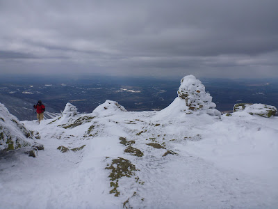
After passing the AMC Greenleaf Hut, We begin on the Greenleaf Trail. First we dip into the trees, then begin climbing sharply out of the treeline and into the alpine zone. Emerging from the trees, we are greeted with stinging winds. I quickly layer up to face the winds. Dark clouds in the distance signal incoming fog and possible precipitation, so we attempt to climb a little faster.
Climbing Mount Lafayette is a steep and strenuous undertaking on any day. Today it is made that much more difficult by the icy windswept conditions. One area in particular, a clean sheet of ice at a very steep incline, requires my most careful attention as I slowly climb. One slip and it could be a long time before I stop.
With my legs screaming, and my lungs still adjusting to the thinned air, we reach the summit of Mount Lafayette! At 5,249 feet in elevation, We feel as if we are at the absolute top of the world! The views are breathtaking, overlooking the vast green and white blanket that is the White Mountains in Winter.
 |
| Shawn and I on the summit of Mount Lafayette |
 |
| Views from Lafayette |
With temperatures below 0 and very high winds, we couldn't stand still to soak it all up for long. We begin descending the opposite side of the mountain to find cover from the wind. Still in shock from the unquestionable beauty, we consult our map and watch and decide we must press on in order to make our destination before sunset. We snack, layer, and begin walking along the sharp ridge line.
 |
| Franconia Ridge |
The ridge line follows along several peaks, and consistently keeps us in an alpine zone, which essentially means we are high enough in elevation where it is to windy for trees or other tall plants to exist. This special climate makes one feel as if they are walking in another world, or hiking in an arctic place.
Aside from the high winds and cold, and the burning sensation in my legs, I am in absolute bliss to be hiking along this ridge! The sense of accomplishment, the views, the unique terrain... this is why I love to hike.
We continue along the ridge, eventually bagging Mount Lincoln. The ridge trail proceeds past, and we partake in a climb to the top of Mount Haystack. Our third peak of the trip, one we will ascend a second time before our trip is finished.
 |
| Summiting Haystack |
The sun is getting low in the sky, and our intended destination is a tent site on the side of the next peak along the ridge, Mount Liberty. Without haste, we begin towards Liberty, this time dipping back within the treeline.
 |
| Mount Liberty |
In some ways, I would say this was the hardest part of the trip. The trail leading off of Haystack was difficult. Steep and deep with snow, it meandered through low sharp branches that hung in the trail under the weight of snow and ice.
We were also pretty exhausted at this point. Cold, hungry, and tired, we hiked this difficult stretch that felt it went on forever. Eventually we did emerge to the sign that pointed to our trail, Liberty Springs. We were so glad to see it! We scrambled down the steep path, and immediately set up camp.
 |
| Sunset from our camp |
With the sun setting and temperatures dropping, we waste little time setting up. We began cooking our dinner, but began to feel cold, so we took our hot meals to our sleeping bags and enjoyed refueling with hot beef stew and buttery potatoes.
 |
| cooking dinner |
A very cold night it was, our breath would freeze moments after leaving our mouths. We stayed warm though, thanks to layering and remaining in our toasty sleeping bags.
The next morning we had our hot oatmeal and packed up camp. We proceeded towards Mount Liberty. About halfway there, we stop to warm ourselves with some hot tea. We then slack packed to the summit of Mount Liberty. Emerging once again from the trees, we are graced with yet another stunning peak with rewarding views beyond imagination.
 |
| the view toward Flume Mountain |
We spot Mount Washington in the distance. At 6,288 feet, Washington is
the tallest mountain in the Northeast. It's pure white top, ringed with clouds, towers over all in the region.
 |
| Washington in the distance |
After loading up our packs, we make the long hard climb back to Haystack, enjoying the warming sun. The coming warmth of the day softens the snow considerably, and at one point my hiking partner fell through the crust. He was waist deep before he was able to stop himself!
Enjoying the views one last time from this peak, we then proceed down Rolling Waters Trail. A long trot down the mountain side, following alongside a ravine and frozen waterfalls. At times, the only reasonable way to navigate our way down was to sit and slide down the slick ice! Usually this went well, and was actually fun.
In the end and looking back, this hike was more than enough preparation for the Appalachian Trail. It was physically demanding, and certainly colder than anything I would actually expect to see on my thruhike. If I could handle this, I can handle the A.T.... Then again, it is going to be a unique challenge in that I will have to wake up, and do it again. And then again. And so on...
I feel I am ready. It will be difficult, and I think the biggest challenge will be missing people. The destination is the journey, though, and I intend on enjoying my long hike. Hopefully, I will make it as far as this ridge, so I can climb to it once more. Just going to keep following the white blazes north....


No comments:
Post a Comment